Geo Tagging Your Photos
Last week Flickr introduced the highly anticipated Geo Tag capabilities so that you can now associate a location with your photos. Its extremely easy to get started doing this, all you have to do is log into your flickr account, select the "manage" link, and then select the "Map" tab. Now geotag your photos by navigating around the Yahoo! map, zooming in/out and dragging photos onto the map. Flickr allows you to both privately and publically tag photos.
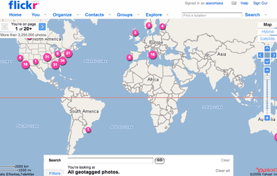
What makes geotagging so cool is that it provides you with a whole new way to view flickr photos. Now you can navigate a map of all your (and other people's) photos zooming in and out to get more precise locations for pictures to view. You can associate a photo with any latitude/longitude coordinates which allow you to get extremely precise tagging photos only a few feet apart. This will make it easier to connect with other flickr users in your area that have similar interests. Not to mention it gives you a way to easily access photos of a particular place.
Here are a couple very short videos (less than a minute) that will have you geotagging your flickr photos like a pro in no time:
Geotagging your flickr photos.
How to explore photos on the map.
Whats really amazing is that over just one week of this feature being released there are already over 3 million geo tagged photos on flickr!

0 Comments:
Post a Comment
<< Home